Opening Minds and Hearts with a U.S. Map
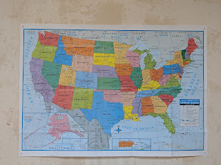
This past Saturday, we hosted a few friends and their families at our house, and the U.S. map we have hanging in our kitchen was quite the hit! Here's a picture of it on our wall:

The Inspiration
I bought this map to educate my kids on the U.S. states and their capitals, but I don't view it as a rote memorization exercise. At the root of it, I want my kids to understand that the United States is comprised of much more than just New York (where we live) and California. That there are many different kinds of people in the country who live their lives in many different ways and have all different ways of thinking. I want my kids to know this, in their core.
The inspiration for the map was an exchange I had with a childhood friend several months ago. We hadn't seen each other in a while and were catching up on life events over dinner. I shared that I had taken a class at a local gun range on how to shoot a rifle, and this elicited a visceral reaction that surprised even me. My friend didn't seem able to hear me when I explained that a) it was fun, and b) I felt it was important as a way to understand large swaths of the country, for much of which firearms are an integral part of life and culture.
And this small interaction perfectly highlighted to me the cultural divide in the nation. Here was a highly educated and otherwise open-minded person, who absolutely shut down when faced with a view on guns that was not in line with theirs. So how did we get from guns to maps? I believe that taking the time to learn about all the states and treating them with equal importance and emphasis, the same amount of time we spend learning Mandarin and math, will work to inculcate my kids with the understanding that everyone's experiences matter and every person, regardless of their lifestyle or beliefs, has inherent value.
How We Use It
In our day-to-day, when a U.S. state or city comes up in conversation, like when my husband travels for work or my kids think about their grandparents' house in New England or visiting Disney World again, we'll refer to the map. We find the state or city and talk about the surrounding geography, such as adjacent bodies of water or landmarks. For a while, we were also doing "State of the Day" and learning a new state's location and capital every day. This has slowed down a bit, as we're trying to get a handle on Nevada / Carson City vs. Utah / Salt Lake City. Finally, we pick a new state every Friday to explore in depth and I'll cover this in a future post.
Unexpected Reception
When I bought this map, I did not foresee how much my kids and I would enjoy exploring it. Nor did I expect the fascination it would hold for visitors to our home. As I mentioned, we tacked the map up on a wall in our kitchen, which is where we spend much of our time. Whenever we have friends over, the map inevitably becomes a source of conversation, both as an object in itself, but also as a conduit to reminiscing about past travel, discussions on future travel, and musings on geographical knowledge. Several times this past Saturday, our friends grouped themselves around the map as a focus of conversation. And one of my friends told me on Sunday, during our kids' swim class, that she has been inspired to purchase a map for her own family.
In Conclusion
This one paper map was a $5 investment and has given us so much enjoyment and expanded our horizons. It is opening our minds to other parts of the country and its people, and serves as a link to the past and future in terms of travel experiences. Once we have a firm grip on the U.S. map, I hope to delve deeper into the world globe I purchased for my kids' room. Can't wait!

Comments
Post a Comment